


SKU/Artículo: AMZ-B0DSHJ24B4
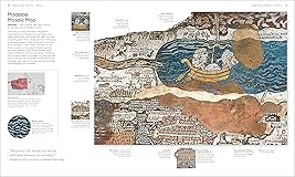
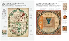
Maps, Annotated: The World's 300 Greatest Maps Explained
Format:
Hardcover
Detalles del producto
Disponibilidad:
En stock
En stock
Peso con empaque:
2.58 kg
2.58 kg
Devolución:
Sí
Sí
Condición
Nuevo
Nuevo
Producto de:
Amazon
Amazon
Viaja desde
USA
USA
Sobre este producto
- This fascinating history of cartography includes more than 300 maps, from the ancient world to the present day. Combining stunning reproductions with clear annotations and pull-out details, it is an expertly curated selection of the finest examples ever created. Delve into Maps, Annotated and find out how the Polynesians used sticks to chart their way across the Pacific, what a meridian is, and where dragons were said to lurk. Discover ancient Chinese star maps, decipher medieval Mappa Mundi, and find out how the world is split into time zones. Organized chronologically, the book features maps from all over the world, explaining key elements such as compasses, scales, symbols, and geographic features. Each map is also set in historical context, making Maps, Annotated a complete overview of the history of cartography. From Babylonian world maps to the Aztec map of Tenochtitlán and the Gaia map of the Milky Way, immerse yourself in the most intriguing maps ever created. Comprehensive and lavishly illustrated, Maps, Annotated is a must for all armchair explorers.
U$S 61,63
31% OFF
U$S 42,50
IMPORTÁ FACIL
Comprando este producto podrás descontar el IVA con tu número de RUT
NO CONSUME FRANQUICIA
Si tu carrito tiene solo libros o CD’s, no consume franquicia y podés comprar hasta U$S 1000 al año.
U$S 61,63
31% OFF
U$S 42,50
con envío
Compra protegida
Disfruta de una experiencia de compra segura y confiable
![]() Garantía de entrega
Garantía de entrega
Con Tiendamia todas tus compras cuentan con Garantía de Entrega o devolución total de tu dinero.
Compras 100% seguras y garantizadas, para que pidas lo que soñás y lo recibas del mundo a tu puerta.
Saber más.
Tarjetas prepagas, debito, y credito
Paga hasta en 12 cuotas sin interés con tarjetas de crédito.
Visa
Mastercard
American Express
Dinners
Discover
Lider
Midinero
OCA
OCA Blue
Tarjeta PREX
Pagos a través de PayPal
Paga en dólares con Tarjetas internacionales a través de PayPal.
PayPal

